Geography Awareness Week: November 13-17, 2023
Exploring geography deepens our understanding of the planet. Brown students are invited to join IBES in celebrating Geography Awareness Week with special activities grounded in building our awareness of place.
Geography Awareness Week: November 13-17, 2023
Exploring geography deepens our understanding of the planet. Brown students are invited to join IBES in celebrating Geography Awareness Week with special activities grounded in building our awareness of place.
Photo Contest
Geography has long been devoted to describing and understanding the natural and urban landscapes, inhabitants, and phenomena of Earth. To celebrate the Geography Awareness week, we sponsored a photo contest, and more than 20 students have submitted photos in three categories.
Here are the winners!
Category 1: Natural Landscapes and/or Geology

1st Place: MATANUSKA GLACIER, ALASKA | Exploring the beauty of the Matanuska Glacier's crevasses in Alaska. Submitted by Rachel Brooks.
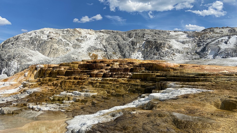
2nd Place: YELLOWSTONE NATIONAL PARK, WYOMING | On a sunny day, the Mammoth Hot Springs terraces display vibrant hues of gold, brown, and white. Submitted by Claire Xu.
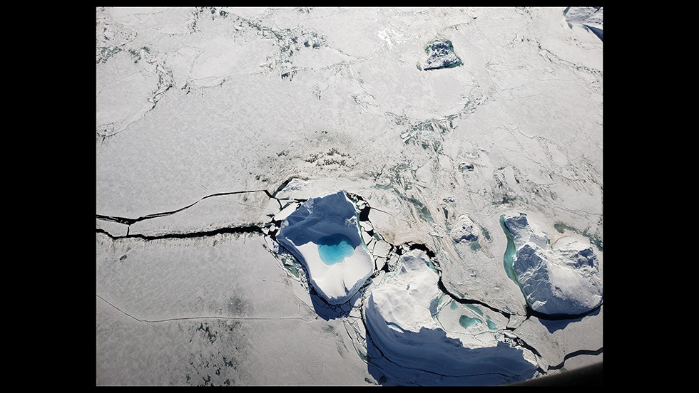
3rd Place (tie): QAANAAQ, GREENLAND | Ice cracking and bright blue melt ponding on the surface as sea ice breakup arrives near Qaanaaq, Greenland in June 2022. Submitted by Sarah Esenther.
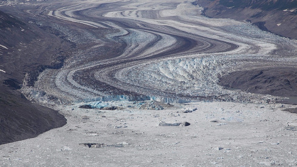
3rd place (tie): Kluane National Park and Reserve, Yukon Territory, Canada | Lowell Glacier at the end of its surge cycle, retreats by calving icebergs into its proglacial lake. Submitted by Kaiyuan Wang.
Category 2: Urban Landscapes
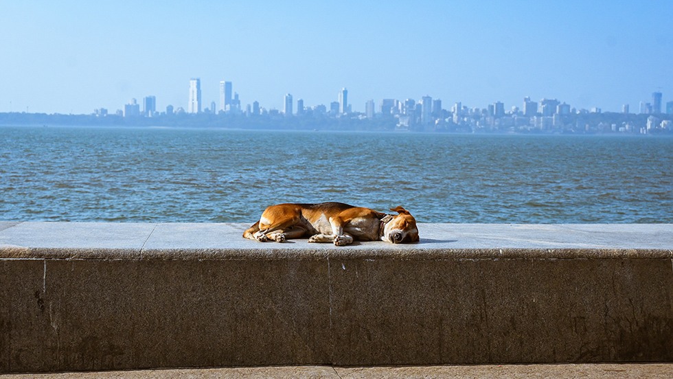
1st place: MUMBAI, INDIA | On a cool winter day, a dog takes a nap by the Mumbai waterfront under the city skyline. Submitted by Sofia Kassalow.
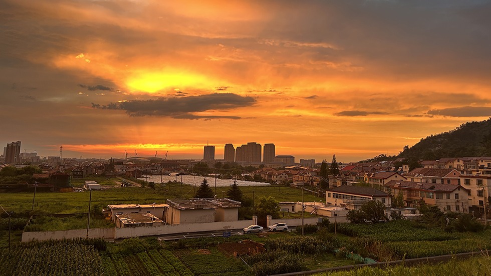
2nd place: LIANYUNGANG, JIANGSU, CHINA | Sunset over the expanding suburb of Lianyungang city, urbanization slowly encroaching into farmland. Submitted by Kaiyuan Wang.
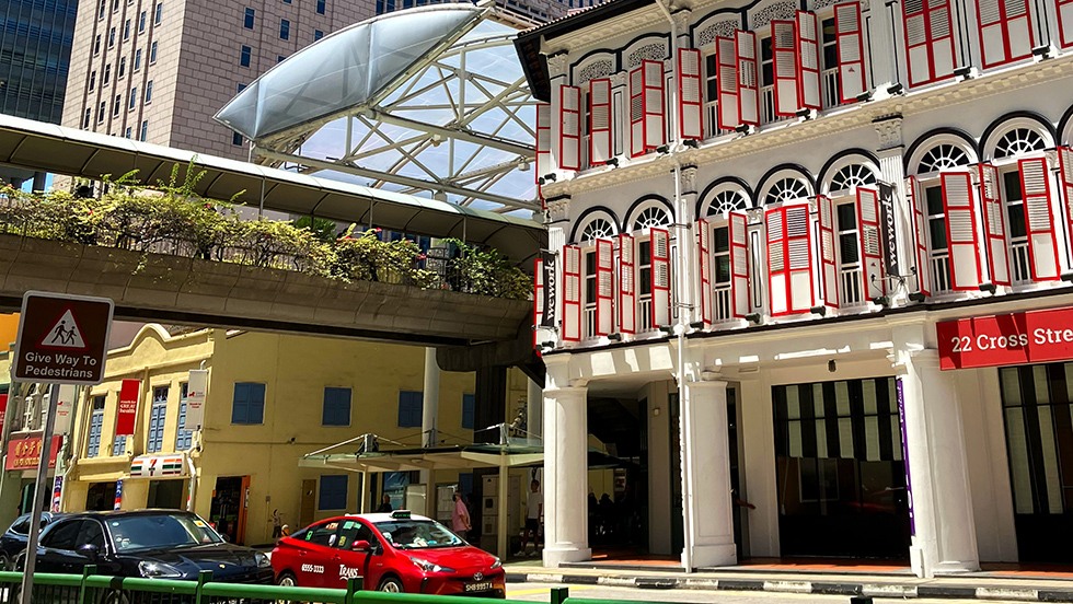
3rd place (tie): CROSS STREET, SINGAPORE | Cultures and histories converge in Singapore's densely constructed built environment. Submitted by Jessica Simon.

3rd place (tie): Venice, Italy | A view down a canal in Venice. Submitted by Mya Collins.
Category 3: People and/or Culture
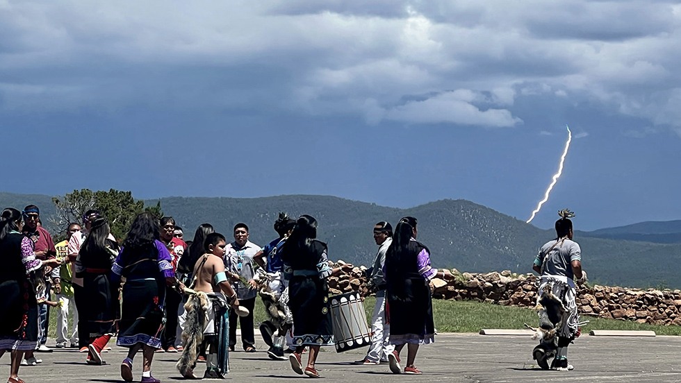
1st place: PECOS NATIONAL HISTORIC PARK, NEW MEXICO | The Jemez people have ancestral claims to Pecos Pueblo and are seen dancing to honor their ancestors and bring life-giving rain. In the distance, a thunderbolt visibly touches the ground; in the background is a visible 14th-century wall section. Meanwhile, the foreground shows Native dancers in traditional garb atop a modern parking lot, showing in a singular image the survival and persistence of Native culture in this area where I work and study. Submitted by Mark Agostini.

2nd place: KASHGAR, XINJIANG, CHINA | Baked Bao Buns (烤包子) cooked in tandoor, a traditional Uyghur delicacy popular in western China, usually filled with lamb, onion, potatoes, and spices. Submitted by Kaiyuan Wang.
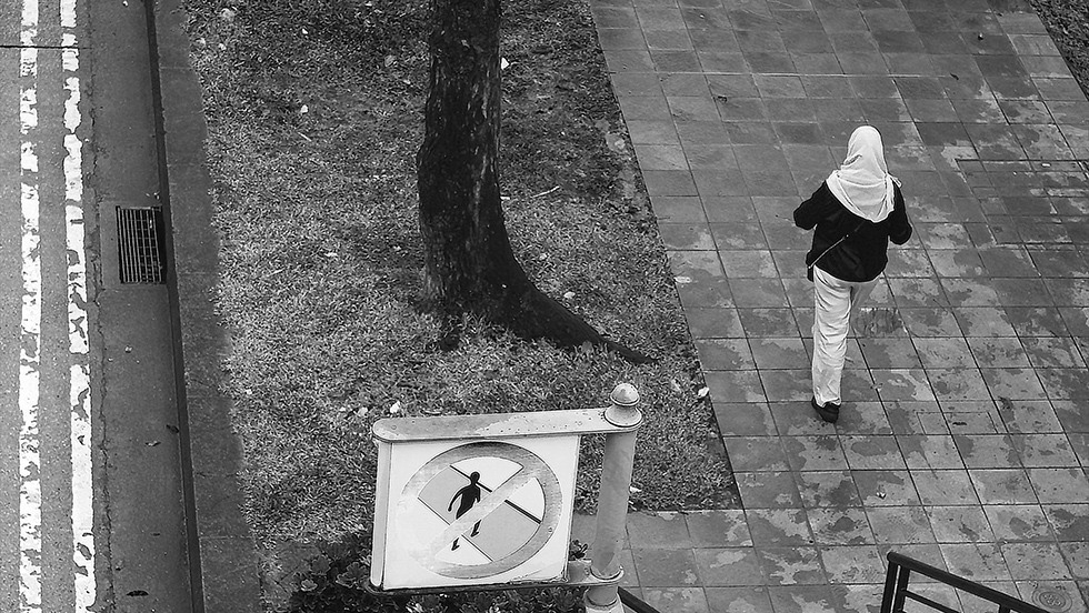
3rd place (tie): HILL STREET, SINGAPORE | A woman walks in downtown Singapore. Submitted by Jessica Simon.
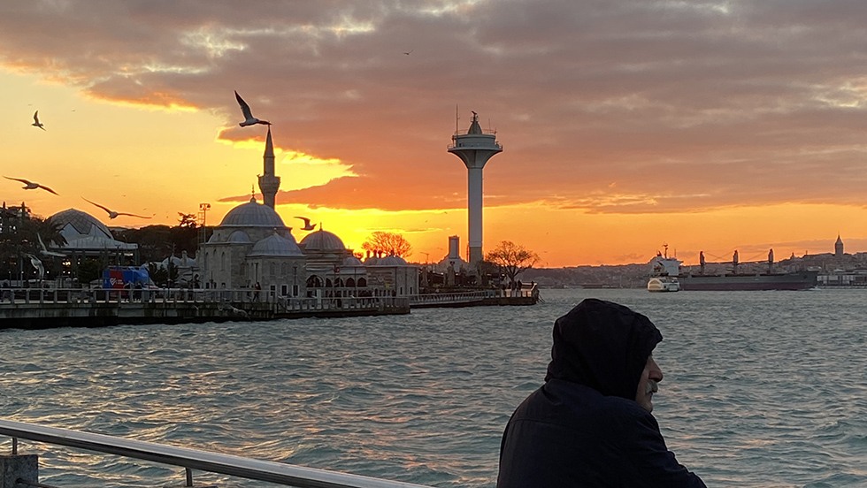
3rd place (tie): ISTANBUL, TURKEY | An elderly man facing the waters at sunset in Istanbul. Submitted by Gloria Kuzmenko-Latimer.

3rd place (tie): PARIS, FRANCE | Visitors Gaze Upon the Louvre. Submitted by Mya Collins.
GIS Day: November 15
Join us on Wednesday, November 15, 2023, as we celebrate Geographic Information Science (GIS) Day at Brown University. The event is free and open to all! GIS Day is an annual event celebrating geographic information systems-based technologies.
Schedule
10:00 – 10:45 am
Virtual Geographic Information Science (GIS) Coffee Social
Start GIS Day with refreshments and socialize with the community. The event will be through zoom and open to everyone.
Hosted by Seda Şalap-Ayça (Department of Earth, Environmental and Planetary Sciences and the Institute at Brown for Environment and Society)
11 am – noon
#BrownGISday2023 Mapathon
Mapping areas of the world that are stricken by disasters to provide aid. The leader gets a GIS Day t-shirt!
This event offers a hybrid experience. Earth Lab (85 Waterman St, Providence), our physical venue, has a capacity for 20 participants, and registration is mandatory for in-person attendance. Please fill out this form to show your interest of in-person participation. Alternatively, you can access the Zoom link for remote participation.
Hosted by Seda Şalap-Ayça (Department of Earth, Environmental and Planetary Sciences & Institute at Brown for Environment and Society)
1 – 1:50 pm
Mapping OpenStreetMap Data with Python
Get ready to learn the basics of OSM data and sharpen your Python powers! Access the notebook and repository on GitHub.
This event offers a hybrid experience. Earth Lab, our physical venue, has a capacity for 20 participants, and registration is mandatory for in-person attendance. Please fill out this form to show your interest of in-person participation. Alternatively, you can access the Zoom link for remote participation.
Hosted by Seda Şalap-Ayça (Department of Earth, Environmental and Planetary Sciences and the Institute at Brown for Environment and Society)
2 - 2:50 pm
The Ocean State Spatial Database Project
A presentation and demo of this free and open-source resource for Rhode Island spatial analysis and thematic mapping, created by the GeoData@SciLi team at the Brown University Library. We will cover how the database was created with QGIS, Python, and spatial SQL. Download the database and view some of the project code on GitHub.
This event offers a hybrid experience. Earth Lab, our physical venue, has a capacity for 20 participants, and registration is mandatory for in-person attendance. Please fill out this form to show your interest of in-person participation. Alternatively, you can access the Zoom link for remote participation.
Presenter Frank Donnelly (Head of GIS & Data Services, Brown University Library)
These activities are hosted by Institute at Brown for Environment and Society and the Department of Earth, Environmental, and Planetary Sciences.