Each year, fossil fuel combustion and other industrial processes release billions of tons of carbon into the Earth's atmosphere. About half of this carbon remains suspended there, while some is taken up by the oceans and temperate forests. But what happens to the rest?
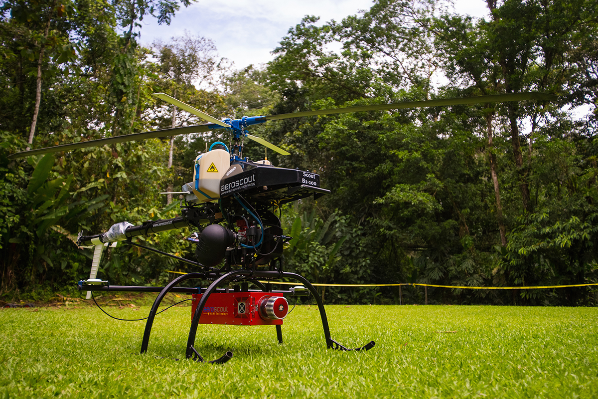
Scientists believe that the "missing" carbon ends up being stored in tropical forests; however, the mechanism underlying this uptake remains unclear. Now, a new project spearheaded by IBES Fellow James Kellner aims to quantify the mechanisms of exchange of carbon between the atmosphere and the tropics by conducting remote sensing measurements in the Atlantic lowlands of Costa Rica. His tool of choice? A suite of sophisticated technology carried by a state-of-the-art unmanned helicopter.
The Missing Sink
Ecologists talk about carbon in terms of its different pools, or reservoirs, such as the oceans, forests, and atmosphere. Movement, or flux, between pools occurs due to biological processes, like photosynthesis and respiration, and geological processes, like rock weathering. When the flux of carbon into a pool – say, the atmosphere – is greater than the flux out, that pool is said to be a net sink for carbon; conversely, when the flux of carbon out of a pool is greater than the flux into it, that pool represents a net source.

Understanding these variables and the relationships among them is essential to tallying up the global carbon budget – especially since this budget currently contains a significant amount of uncertainty.
"We can quantify the sizes of pools and fluxes. But when added up, the budget doesn't balance. There's some CO2 emitted every year that does not remain in the atmosphere but is not directly accounted for by any known sink," explains Kellner.
Tropical forests may hold the key to understanding this so-called "missing sink" of carbon. Some researchers have suggested that, in the presence of a more carbon-rich atmosphere, photosynthesis enables tropical trees to grow faster. According to Kellner, however, there is no decisive evidence that this is the case.
"Some data show that aboveground carbon is accumulating, but we haven't ruled out a number of alternatives," he says. "In part, the problem is that the data that have been available are not directly related to what we want to understand."
Historically, scientists have measured carbon fluxes by making repeated measurements of tree diameter at a height of 1.3 m aboveground. As a tree grows over time, its diameter increases, and scientists have developed scaling equations that allow them to convert diameter into mass, in the same way that a person's height could be used to predict their weight.
But Kellner is skeptical of the assumptions underlying this method. "Not all growth shows up in tree diameters," he says, "and tree diameters can change for reasons unrelated to growth."
In his view, scientists have long needed a new way to measure the amount of carbon being taken up by tropical ecosystems. Enter the Brown Platform for Autonomous Remote Sensing (BPAR), an unmanned helicopter that brings together imaging spectroscopy, airborne LiDAR, and methods from computer vision to characterize the structure, composition and chemistry of natural landscapes in high spatial resolution.

Kellner is hopeful that BPAR's advanced instrumentation will capture the Costa Rican forest in a new way, enabling his team to gain insight into the physiological processes that drive carbon fluxes in the tropics.
A Spectral Solution
One way they hope to do this is by employing the drone's imaging spectrometer, an instrument that makes high-resolution measurements of the radiation reflected or emitted by substances in its field of view. These measurements reveal patterns that tell researchers something about the material that was analyzed. For instance, the reflectance spectrum of a green leaf will reveal a peak at wavelengths that correspond to green light as well as an abrupt increase in the near-infrared, a large bump that scientists call the red edge.
"If you see that, you're almost definitely looking at a green plant," explains Kellner.
"And there are more subtle features in the spectrum that tell us about the composition of the material in the sensor's field of view," he continues. "For example, whether the pixel contains soil, water or vegetation. Is it green vegetation, or dry? This kind of technology can also produce measurements of chemical properties in some cases."
Of course, spectroscopic measurements can do far more than simply identify leaves or woody biomass. Indeed, Kellner and the team believe that conducting imaging spectrometry of the tropical forest canopy will also help to quantify the carbon flux due to photosynthesis, the process by which plants take up CO2 and employ it to make energy.
Examining Molecular Machinery
At the subatomic level, sunshine streaming through a forest canopy looks somewhat different from the diffuse, warm light we humans are familiar with. At such tiny scales, photons bombard chlorophyll molecules, occasionally colliding with enough strength to excite a bound electron to a higher energy state. This energized electron can be passed to other chlorophyll molecules in a photosynthetic process called photochemical quenching. Photochemical quenching is the ideal fate for an excited electron because it results in the production of molecules that plants use to remove CO2 from the air - but it can only occur as long as the plant's machinery has available vacancies.
In the event that the plant's capacity for photosynthesis is saturated, it has two remaining options for ridding itself of an excited electron: emitting it as extraordinarily dim fluorescence, which can ultimately damage the plant's machinery, or releasing its excess energy as heat in a relatively harmless process called non-photochemical quenching. The trick, for scientists, is to differentiate the three mechanisms, a goal that is complicated by the fact that neither photochemical quenching nor non-photochemical quenching can be measured directly in ecosystems.
But fluorescence, although extremely faint, is detectable. BPAR's high-resolution imaging spectrometer will enable Kellner's team to quantify this fluorescence by making repeated measurements of the rainforest canopy under a variety of different conditions.
Additionally, by measuring the net flux of carbon between the forest and atmosphere, the team should be able to build a model that will allow them to infer the total amount of photochemical quenching that is occurring in the forest. And once they know the contributions from two out of three photosynthetic mechanisms – in this case, fluorescence and photochemical quenching – they will be able to deduce that of the third, completing the triad.
In other words, BPAR's ability to detect fluorescence is like a key that will unlock the scientists' ability to paint a more complete picture of photosynthesis and, therefore, better identify the determinants of carbon fluxes in tropical forests.
Then, Kellner and his team will finally be able to take on a wider goal: critically evaluating the physiological underpinnings of carbon exchange between tropical forests and the atmosphere. Ultimately, Kellner hopes that the results of this evaluation will help determine whether or not tropical forests are likely to indeed be the "missing sink".
"If we can get to the point, as a discipline, where we can accurately infer carbon fluxes from fluorescence, then we will understand the uptake side of the equation," he says.
Sophisticated and Practical
Imaging spectroscopy is not BPAR's only specialty. The drone also carries high-resolution visual imaging equipment and a LiDAR sensor.

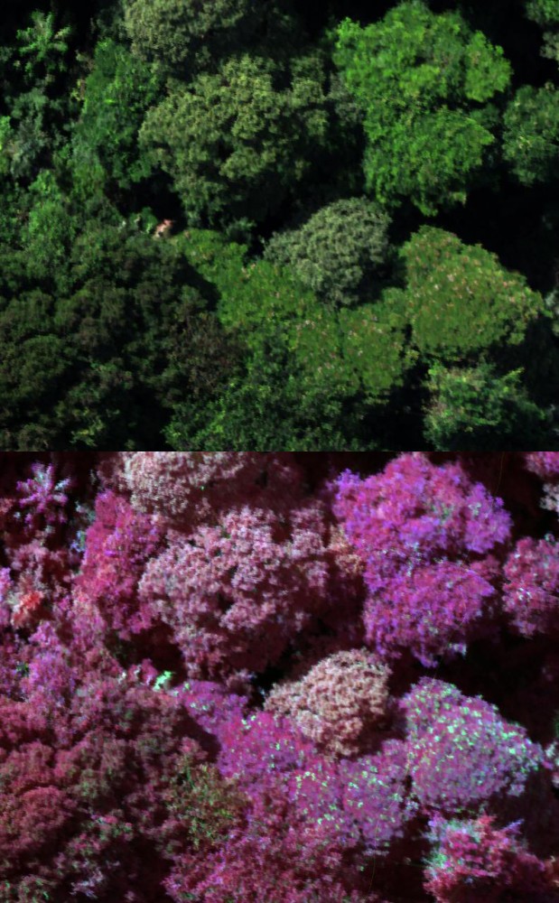
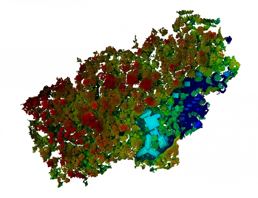
LiDAR, or Light Detection And Ranging, is a technology widely used in remote sensing that measures the amount of time it takes for pulses of light to bounce off a target and return to a sensor. After calibration for location and direction of fire, these data points can be transformed into an elevation map – in this case, of the rainforest canopy. Researchers can combine the results of spectroscopy and digital imaging with the elevation map created by LiDAR in order to create detailed false-color images of the forest from above.
"This allows us to ‘see' in wavelengths that are otherwise invisible to the human eye, like near infrared." explains Kellner. "Then you can visualize how biological materials are structured spatially in 3D. It's powerful. Things become clear when you can see in that way."
BPAR's strength lies, in part, in its flexibility. "With pixels as small as 1 cm, it increases by one to two orders of magnitude the spatial resolution of measurements relative to other airborne imaging spectroscopy systems," he says. "And because the cost of operation is more manageable than a traditional remote sensing program, BPAR can be deployed repeatedly and frequently."
"The timing of data collection can be dictated by the scientific questions," he adds, "rather than the questions being dictated by the timing of data collection."
The Brown Platform for Autonomous Remote Sensing boasts cutting-edge instrumentation and the capacity for extraordinarily high spatial resolution, all at the hands of a brilliant team of researchers and technicians. But, Kellner emphasizes, its real value lies in the potential it offers to science.
"[BPAR] is not just a technical flourish," he says. "What it's really about is about generating the ability to collect the right kinds of measurements to answer the questions that are unresolved."
Kellner's research collaborators include IBES faculty fellows Jung-Eun Lee, Jack Mustard, and Stephen Porder; Brown faculty member Ralph Milliken; staff members Henry Johnson and Joe Kendrick; post-doctoral scholars Sandra Wiseman and Xi Yang; graduate students K.C. Cushman and Carlos Silva; and Brown undergraduate Lucas Toh. The project also includes David and Deborah Clark of the University of Missouri. BPAR was built by Swiss company Aeroscout.
The project is funded by the National Science Foundation (GR526257).